
Lego Road image for Drone
Home » Dataset Download » Lego Road image for Drone
Lego Road image for Drone
Datasets
Lego Road image for Drone
File
Lego Road image for Drone
Use Case
Lego Road image for Drone
Description
Discover how to process and analyze images to predict drone movements. Learn to categorize images into forward, left, and right movements, preprocess data, and train predictive models for enhanced drone navigation and autonomous operations.
Description:
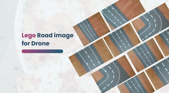
This folder contains three distinct types of images representing various movements: forward, left, and right. Our task involves reading these images into a digital array, which will enable us to analyze and predict the next action of the drone.
Download Dataset
Here’s a detailed breakdown of the process:
Image Categorization:
- Forward Movement: These images depict scenarios where the drone needs to move straight ahead.
- Left Movement: These images illustrate situations where the drone needs to turn or move to the left.
- Right Movement: These images show instances where the drone should turn or move to the right.
Image Preprocessing:
- Reading Images: Use an appropriate library to read and load the images from the folder into a digital format.
- Resizing and Normalizing: Standardize the size of the images and normalize the pixel values to ensure consistent input for the analysis model.
- Labeling: Assign labels to each image based on its movement category (forward, left, right).
Data Storage:
- Store the preprocessed images in a digital array, with each image associated with its respective label. This array will serve as the dataset for further analysis.
Analysis and Prediction:
- Feature Extraction: Extract relevant features from the images, such as edges, shapes, and textures, which are indicative of the movement type.
- Model Training: Use machine learning algorithms to train a predictive model on the labeled dataset. This model will learn to recognize patterns corresponding to each movement type.
- Prediction: Utilize the trained model to analyze new images and predict the drone’s next action based on the detected patterns.
Applications:
- Real-Time Navigation: Implement the predictive model in the drone’s navigation system to enable real-time decision-making based on visual inputs.
- Autonomous Operations: Enhance the drone’s autonomous capabilities by integrating the model with other sensors and control systems for seamless movement.
This dataset is sourced from Kaggle.
Contact Us

Quality Data Creation

Guaranteed TAT

ISO 9001:2015, ISO/IEC 27001:2013 Certified

HIPAA Compliance

GDPR Compliance

Compliance and Security
Let's Discuss your Data collection Requirement With Us
To get a detailed estimation of requirements please reach us.