
Geolocated Imagery Dataset (Scotland)
Geolocated Imagery Dataset (Scotland)
Datasets
Geolocated Imagery Dataset (Scotland)
File
Geolocated Imagery Dataset (Scotland)
Use Case
Geolocated Imagery Dataset (Scotland)
Description
Explore our Geolocated Imagery Dataset from Scotland 2019, featuring urban and rural images for geolocation algorithm development.
Description:
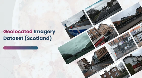
This dataset offers a comprehensive collection of geolocated images captured in Scotland by the Defence Science and Technology Laboratory (Dstl) in February 2019. The dataset is designed to support the development and testing of algorithms that can infer an image’s geographical location based on its visual content rather than relying solely on metadata. This capability is particularly valuable in defense, security, and emergency scenarios, where images may lack precise metadata or timestamps but still need to be geolocated.
Download Dataset
Key Use Cases
One of the primary defense applications for this dataset is to assist in locating hostages or other persons of interest from visual media such as photos or videos sent by captors. In such critical cases, intelligence analysts may only have limited visual data, such as one or two images, and may lack accurate metadata regarding the time or location of the capture. This dataset aids in the creation of machine learning algorithms capable of analyzing the content within the images—such as landscapes, buildings, or natural features—to predict the location.
Dataset Composition and Structure
The dataset consists of a variety of images representing both urban and rural environments, providing diverse visual cues such as buildings, streets, landscapes, and natural elements (e.g., forests, hills). Images were captured using a mobile phone, resulting in mixed quality, a deliberate decision to simulate real-world conditions where image quality may vary. These variations in quality and orientation challenge algorithm development, ensuring robustness across different scenarios.
Geolocation Accuracy
Each image in this dataset is accompanied by geolocation data, which has undergone manual inspection and corrections to mitigate inaccuracies caused by mobile GPS lag. The dataset boasts an accuracy within 100 meters for all images, with most achieving significantly higher accuracy. This ensures that the dataset is suitable for high-precision geolocation tasks, providing a reliable foundation for model training and evaluation.
Privacy and Data Modifications
To safeguard privacy, all identifiable faces and vehicle license plates in the images have been blurred. Apart from these modifications, the images have been kept in their original form to preserve the authenticity and realism of the dataset. The images span a range of angles, orientations, and times of day, making them ideal for training models that must function under variable conditions.
Data Quality and Variety
The dataset emphasizes realistic image conditions, offering a diverse range of visual content:
- Urban and rural settings.
- Varied lighting and weather conditions.
- Different image orientations and angles to simulate real-world data variability.
This dataset is sourced from Kaggle.
Contact Us

Quality Data Creation

Guaranteed TAT

ISO 9001:2015, ISO/IEC 27001:2013 Certified

HIPAA Compliance

GDPR Compliance

Compliance and Security
Let's Discuss your Data collection Requirement With Us
To get a detailed estimation of requirements please reach us.