
Ship Dataset with annotations
Ship Dataset with annotations
Datasets
Ship Dataset with annotations
File
Ship Dataset with annotations
Use Case
Ship Dataset with annotations
Description
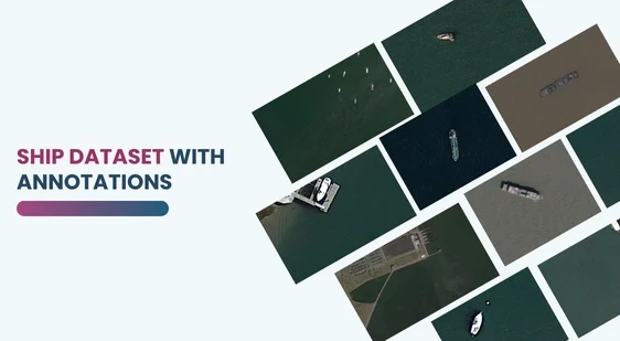
Discover the Aerial Ship Detection Dataset with high-resolution PNG images and detailed Pascal VOC XML annotations for ship detection and classification.
Description:
This dataset includes high-resolution aerial images of ships in PNG format, paired with detailed Pascal VOC XML annotations. Each XML file provides object class (“ship”) and precise bounding box coordinates, enabling accurate ship detection and classification. Ideal for maritime surveillance, logistics, and AI model training, the dataset captures ships from various angles, scales, and environments, ensuring robustness for computer vision applications
Download Dataset
The Aerial Ship Detection Dataset is a comprehensive collection of high-resolution aerial images featuring ships of various sizes, types, and orientations. Each image is paired with detailed annotations provided in XML format, enabling precise object detection and classification tasks. This dataset is ideal for training and testing machine learning models for maritime surveillance, shipping logistics, and security applications.
Key Features of the Dataset:
High-Quality Images:
- Images are in PNG format with sharp details to capture ships from multiple angles and scales.
- Designed to meet the needs of computer vision tasks requiring clarity and consistency.
XML Annotations in Pascal VOC Format:
- Each image has a corresponding XML annotation file that provides:
- File Name: The associated image file name
- Image Dimensions: Metadata such as height, width, and depth of the image.
- Object Detection Data:
- Class: Object classification as “ship” or related sub-categories (e.g., cargo ship, speedboat).
- Bounding Box: Precise coordinates identifying the location of ships within the images.
- Each image has a corresponding XML annotation file that provides:
Diverse Scenarios and Variability:
- Images capture ships in different environments, lighting conditions, and weather scenarios, ensuring model robustness.
- Includes varying distances and angles to simulate real-world maritime conditions.
Dataset Structure:
Images:
- Format: PNG
- Depict ships from diverse perspectives, including top-down aerial views.
Annotations:
- Format: XML
- Follow the industry-standard Pascal VOC annotation format for seamless integration with machine learning frameworks.
Applications of the Dataset:
- Maritime Surveillance:
- Improve detection of unauthorized or suspicious vessels.
- Shipping Logistics:
- Enhance tracking and identification of commercial shipping fleets.
- Research & Development:
- Train deep learning models for object detection, classification, and segmentation.
- Autonomous Systems:
- Support AI-driven navigation and monitoring systems for unmanned aerial vehicles (UAVs) or maritime drones.
This dataset is sourced from Kaggle.
Contact Us

Quality Data Creation

Guaranteed TAT

ISO 9001:2015, ISO/IEC 27001:2013 Certified

HIPAA Compliance

GDPR Compliance

Compliance and Security
Let's Discuss your Data collection Requirement With Us
To get a detailed estimation of requirements please reach us.